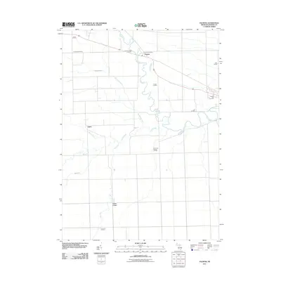
2011 Map of Palmyra
USGS Topo · Published 2011About this map
The River Raisin meanders through the heart of this Lenawee County landscape, its winding course defining the settlement pattern around the community of Palmyra. The area is characterized by a dense network of burial grounds that offer significant value for genealogical research, including the Palmyra Village Cemetery, Scovell Cemetery, and the Zion United Brethren Cemetery. Further south, the rural crossroads of Ogden and Ogden Center are situated amidst a complex drainage system of named waterways like Black Creek and Bear Creek. The presence of the Palmyra Post Office and Betz Airport underscores the mix of traditional town centers and mid-century transportation infrastructure. This topographic record captures the transition of the Michigan countryside, where family-named sites like Luke Farm Cemetery and Crane Cemetery persist alongside agricultural drainage projects like Big Meadow Drain.
Find a feature on this map
20 named features on this map. Tap any name to fly to it.
Don’t see what you’re looking for? This feature index may not catch every label — zoom into the map to look around manually.
Map Details
Editions of this 2011 Palmyra Map
This is the sole edition of this map. No revisions or reprints were ever made.
Other maps of this area

1911 · Wauseon
USGS Topo · 1:62,500

1911 · Swanton
USGS Topo · 1:62,500

1913 · Wauseon
USGS Topo · 1:62,500

1914 · Swanton
USGS Topo · 1:62,500

1935 · Berkey
USGS Topo · 1:24,000

1939 · Berkey
USGS Topo · 1:31,680

1939 · Blissfield
USGS Topo · 1:62,500

1941 · Blissfield
USGS Topo · 1:62,500

1943 · Wauseon
USGS Topo · 1:62,500
1951 · Berkey
USGS Topo · 1:24,000