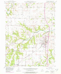
1949 Map of Palmyra
USGS Topo · Published 1977About this map
Palmyra serves as the focal point of this Marion County landscape, showing a dense street grid and significant civic infrastructure such as the Marion County Infirmary. The surrounding countryside is defined by the winding courses of the South Fabius River and the North River, which carve through the townships of Fabius and Liberty. This mid-century survey reveals a highly organized rural society supported by numerous country schools and neighborhood churches, including Salem School and Bethel Church.
Find a feature on this map
30 named features on this map. Tap any name to fly to it.
Don’t see what you’re looking for? This feature index may not catch every label — zoom into the map to look around manually.
Map Details
Editions of this 1949 Palmyra Map
2 editions found

Other maps of this area

1903 · Palmyra
USGS Topo · 1:125,000

1925 · Quincy
USGS Topo · 1:62,500

1932 · Hannibal
USGS Topo · 1:62,500

1936 · Hannibal
USGS Topo · 1:48,000

1944 · Quincy
USGS Topo · 1:62,500

1945 · Hannibal
USGS Topo · 1:62,500

1945 · Quincy
USGS Topo · 1:62,500

1948 · Quincy
USGS Topo · 1:250,000

1949 · Durham
USGS Topo · 1:24,000

1949 · Maywood
USGS Topo · 1:24,000