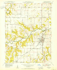
1950 Map of Palmyra
USGS Topo · Published 1950About this map
Palmyra serves as the focal point of this mid-century Missouri landscape, where the Chicago Burlington and Quincy railroad intersects with a grid of rural life in Marion County. The town's layout is meticulously detailed, including the Marion County Infirmary and the Greenwood Cem on its northern outskirts. Beyond the town limits, the terrain is defined by the winding paths of the South Fabius River and North River, which carve through the townships of Fabius and Liberty.
Find a feature on this map
27 named features on this map. Tap any name to fly to it.
Don’t see what you’re looking for? This feature index may not catch every label — zoom into the map to look around manually.
Map Details
Editions of this 1950 Palmyra Map
2 editions found

Other maps of this area

1903 · Palmyra
USGS Topo · 1:125,000

1925 · Quincy
USGS Topo · 1:62,500

1932 · Hannibal
USGS Topo · 1:62,500

1936 · Hannibal
USGS Topo · 1:48,000

1944 · Quincy
USGS Topo · 1:62,500

1945 · Hannibal
USGS Topo · 1:62,500

1945 · Quincy
USGS Topo · 1:62,500

1948 · Quincy
USGS Topo · 1:250,000

1949 · Durham
USGS Topo · 1:24,000

1949 · Maywood
USGS Topo · 1:24,000