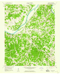
1958 Map of Palmyra
USGS Topo · Published 1959About this map
The Cumberland River carves a dramatic serpentine path through Montgomery County, shaping the settlement patterns of the late 1950s. Communities like Palmyra and Hematite are positioned along the southern banks, where the Louisville and Nashville Railroad parallels the river's course. This transit corridor stands in contrast to the more isolated upland ridges where rural life centered on local institutions such as Central High Sch and the Lone Oak (Cunningham PO).
Find a feature on this map
52 named features on this map. Tap any name to fly to it.
Don’t see what you’re looking for? This feature index may not catch every label — zoom into the map to look around manually.
Map Details
Editions of this 1958 Palmyra Map
4 editions found
Other maps of this area

1931 · Erin
USGS Topo · 1:62,500

1944 · Clarksville
USGS Topo · 1:50,000

1951 · New Providence
USGS Topo · 1:24,000

1951 · Clarksville
USGS Topo · 1:24,000

1951 · Woodlawn
USGS Topo · 1:24,000

1956 · Nashville
USGS Topo · 1:250,000

1957 · New Providence
USGS Topo · 1:24,000

1957 · Clarksville
USGS Topo · 1:24,000
1957 · Woodlawn
USGS Topo · 1:24,000
1957 · Clarksville
USGS Topo · 1:62,500