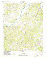
1958 Map of Palmyra
USGS Topo · Published 1986About this map
Cumberland River + Lake Barkley dominates this Montgomery County landscape, winding through a region defined by scattered rural settlements and significant family heritage sites. The 1950s terrain is characterized by deep creek valleys such as Budds Creek and Deason Creek, which served as the backdrop for a network of country churches like Haynes Chapel and Martin Chapel. Local genealogy is well-preserved through numerous family burial grounds, including Sivels Cem, Baggett Cem, and Wickham Cem, many of which are tucked away from the primary thoroughfares like Dotsonville Road.
Find a feature on this map
64 named features on this map. Tap any name to fly to it.
Don’t see what you’re looking for? This feature index may not catch every label — zoom into the map to look around manually.
Map Details
Editions of this 1958 Palmyra Map
4 editions found
Other maps of this area

1931 · Erin
USGS Topo · 1:62,500

1944 · Clarksville
USGS Topo · 1:50,000

1951 · New Providence
USGS Topo · 1:24,000

1951 · Clarksville
USGS Topo · 1:24,000

1951 · Woodlawn
USGS Topo · 1:24,000

1956 · Nashville
USGS Topo · 1:250,000

1957 · New Providence
USGS Topo · 1:24,000

1957 · Clarksville
USGS Topo · 1:24,000
1957 · Woodlawn
USGS Topo · 1:24,000
1957 · Clarksville
USGS Topo · 1:62,500