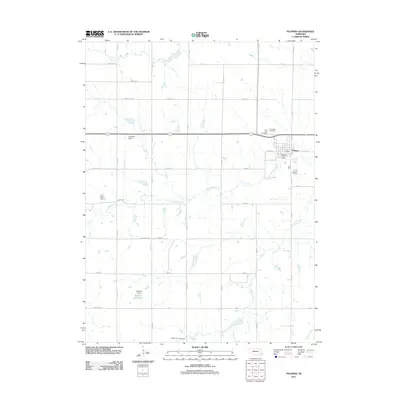
2011 Map of Palmyra
USGS Topo · Published 2011About this map
The village of Palmyra serves as the primary hub in this eastern Nebraska landscape, situated near the winding course of the Little Nemaha River. The township's layout is defined by a rigid grid of rural roads, including Bennet Rd and Yankee Hill Rd, which connect scattered farmsteads across the prairie. Local history is anchored by several sites of repose, such as Saint Leos Cemetery and Rosewood Cemetery north of the village, and Mount Zion Cemetery to the south. Water management is a visible priority for the agricultural community, evidenced by Mueller Reservoir and the Mueller Dam. The presence of the Clearidge Airport and the Palmyra Post Office indicates a settled infrastructure that supports both local transportation and regional communication. Drainage for the surrounding fields is provided by a network of waterways including Hooper Creek, Silver Creek, and Russell Creek, which feed into the larger river system.
Find a feature on this map
39 named features on this map. Tap any name to fly to it.
Don’t see what you’re looking for? This feature index may not catch every label — zoom into the map to look around manually.
Map Details
Editions of this 2011 Palmyra Map
This is the sole edition of this map. No revisions or reprints were ever made.
Other maps of this area

1897 · Lincoln
USGS Topo · 1:125,000

1903 · Weeping Water
USGS Topo · 1:125,000

1929 · Weeping Water
USGS Topo · 1:125,000

1955 · Lincoln
USGS Topo · 1:250,000

1957 · Lincoln
USGS Topo · 1:250,000

1958 · Lincoln
USGS Topo · 1:250,000

1964 · Walton
USGS Topo · 1:24,000
1965 · Firth
USGS Topo · 1:24,000
1965 · Douglas
USGS Topo · 1:24,000
1966 · Bennet
USGS Topo · 1:24,000