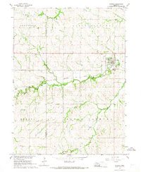
1966 Map of Palmyra
USGS Topo · Published 1968About this map
The Little Nemaha River winds through the heart of this mid-1960s landscape, defining the agricultural and civic layout of the borderlands between Lancaster and Otoe counties. The village of Palmyra serves as a primary hub, situated near the confluence of the river and Hooper Creek. Just to the west, the community of Bennet sits along the Chicago Burlington and Quincy railroad line, which facilitates the region's grain-and-rail economy. Local heritage is preserved in several rural burial grounds, including Rosewood Cem, St Leos Cem, and Mt Zion Cem. Aviation history is noted by the private Bayberry Landing Strip north of the river, while the local topography is divided into civil townships such as Stockton, North Palmyra, and South Palmyra. This survey provides a clear look at the Nebraska prairie before more modern residential expansion, capturing the network of section-line roads and field boundaries.
Find a feature on this map
18 named features on this map. Tap any name to fly to it.
Don’t see what you’re looking for? This feature index may not catch every label — zoom into the map to look around manually.
Map Details
Editions of this 1966 Palmyra Map
This is the sole edition of this map. No revisions or reprints were ever made.
Other maps of this area

1897 · Lincoln
USGS Topo · 1:125,000

1903 · Weeping Water
USGS Topo · 1:125,000

1929 · Weeping Water
USGS Topo · 1:125,000

1955 · Lincoln
USGS Topo · 1:250,000

1957 · Lincoln
USGS Topo · 1:250,000

1958 · Lincoln
USGS Topo · 1:250,000

1964 · Walton
USGS Topo · 1:24,000
1965 · Firth
USGS Topo · 1:24,000
1965 · Douglas
USGS Topo · 1:24,000
1966 · Bennet
USGS Topo · 1:24,000