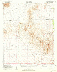
1953 Map of Palo Verde Mountains
USGS Topo · Published 1960About this map
Palo Verde Mountains and the Mule Mountains dominate this arid landscape along the Riverside and Imperial county line in the early 1950s. The survey reveals a network of primitive transportation routes, including an old Stage Line, the Army Road, and numerous Jeep Trails cutting through the desert floor toward water sources like Wileys Well and Clapp Spring. Geologic interest is marked at the Geode Beds and various prospects scattered near Coon Hollow. The eastern edge of a large Naval Reservation borders the western portion of the quadrangle, illustrating the mid-century military footprint in the California desert. Prominent high points like Palo Verde Peak and Thumb Peak serve as landmarks above the broad drainage of the Milpitas Wash.
Find a feature on this map
19 named features on this map. Tap any name to fly to it.
Don’t see what you’re looking for? This feature index may not catch every label — zoom into the map to look around manually.
Map Details
Editions of this 1953 Palo Verde Mountains Map
5 editions found
Other maps of this area

1942 · Blythe
USGS Topo · 1:250,000

1945 · Cibola
USGS Topo · 1:62,500

1945 · Picacho
USGS Topo · 1:62,500

1951 · Picacho
USGS Topo · 1:62,500

1951 · Cibola
USGS Topo · 1:62,500

1952 · Mc Coy Spring
USGS Topo · 1:62,500

1952 · Sidewinder Well
USGS Topo · 1:62,500

1952 · Palo Verde
USGS Topo · 1:24,000

1952 · Ripley
USGS Topo · 1:24,000

1953 · Palo Verde Mountains
USGS Topo · 1:62,500