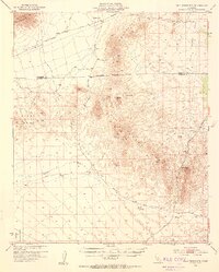
1953 Map of Palo Verde Mts.
USGS Topo · Published 1954About this map
The Palo Verde Mountains and Mule Mountains dominate this arid stretch of the California desert during the early 1950s. The landscape is defined by its geological features and sparse access, featuring the notable Geode Beds and high points such as Thumb Peak and Palo Verde Peak. A few isolated water sources like Clapp Spring punctuate the dry terrain, while the massive Milpitas Wash cuts through the southern reaches of the quadrangle.
Find a feature on this map
16 named features on this map. Tap any name to fly to it.
Don’t see what you’re looking for? This feature index may not catch every label — zoom into the map to look around manually.
Map Details
Editions of this 1953 Palo Verde Mts. Map
5 editions found
Other maps of this area

1942 · Blythe
USGS Topo · 1:250,000

1945 · Cibola
USGS Topo · 1:62,500

1945 · Picacho
USGS Topo · 1:62,500

1951 · Picacho
USGS Topo · 1:62,500

1951 · Cibola
USGS Topo · 1:62,500

1952 · Mc Coy Spring
USGS Topo · 1:62,500

1952 · Sidewinder Well
USGS Topo · 1:62,500

1952 · Palo Verde
USGS Topo · 1:24,000

1952 · Ripley
USGS Topo · 1:24,000

1953 · Palo Verde Mountains
USGS Topo · 1:62,500