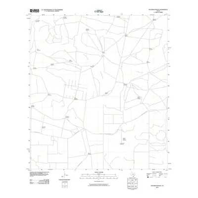
2010 Map of Palomas Ranch
USGS Topo · Published 2010About this map
Palomas Ranch and Baile Camp are the primary points of activity in this arid South Texas landscape, defined by a complex network of private ranch roads and vital water infrastructure. The territory is dominated by seasonal watercourses like Palo Blanco Creek and Arroyo Baluarte, which provide the topographical framework for the region's cattle-ranching operations. A striking density of over twenty named windmills, including Guanajuato Windmill and the Louisiana Windmill, underscores the constant necessity of groundwater management for livestock and residents alike. The map traces local transportation arteries such as Baluarte Creek Rd and Co Rd 101, which connect remote outposts like Cayetano Windmill and Tejon Windmill to the broader county network. This survey captures a moment of modern ranch life where traditional place names and functional landmarks remain essential to navigating the Brooks County scrubland.
Find a feature on this map
30 named features on this map. Tap any name to fly to it.
Don’t see what you’re looking for? This feature index may not catch every label — zoom into the map to look around manually.
Map Details
Editions of this 2010 Palomas Ranch Map
This is the sole edition of this map. No revisions or reprints were ever made.
Other maps of this area

1921 · Falfurrias
USGS Topo · 1:125,000

1956 · Laredo
USGS Topo · 1:250,000

1963 · Premont West
USGS Topo · 1:24,000

1963 · Cage Ranch
USGS Topo · 1:24,000

1963 · Falfurrias
USGS Topo · 1:24,000

1968 · Palomas Ranch NW
USGS Topo · 1:24,000

1968 · Palomas Ranch SW
USGS Topo · 1:24,000

1968 · Palomas Ranch SE
USGS Topo · 1:24,000

1968 · Palomas Ranch
USGS Topo · 1:24,000
1969 · Laguna Del Toro
USGS Topo · 1:24,000