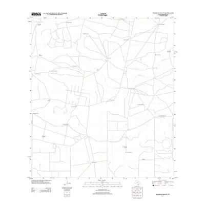
2013 Map of Palomas Ranch
USGS Topo · Published 2013About this map
Palomas Ranch and Baile Camp are the primary named settlements in this section of Brooks County, characterized by a complex network of private ranch roads and water infrastructure. The landscape is dominated by the seasonal drainage of Palo Blanco Cr in the north and Arroyo Baluarte to the southeast. The map is particularly notable for its dense concentration of named windmills, which serve as essential landmarks and water sources for the cattle industry in this semi-arid region. These include family and place-named features such as Guanajuato Windmill, El Ballo Windmill, Cayetano Windmill, and Punta Monte Windmill. The presence of these named sites provides a window into local land ownership and the historical reliance on groundwater for ranching operations across the South Texas plains.
Find a feature on this map
31 named features on this map. Tap any name to fly to it.
Don’t see what you’re looking for? This feature index may not catch every label — zoom into the map to look around manually.
Map Details
Editions of this 2013 Palomas Ranch Map
This is the sole edition of this map. No revisions or reprints were ever made.
Other maps of this area

1921 · Falfurrias
USGS Topo · 1:125,000

1956 · Laredo
USGS Topo · 1:250,000

1963 · Premont West
USGS Topo · 1:24,000

1963 · Cage Ranch
USGS Topo · 1:24,000

1963 · Falfurrias
USGS Topo · 1:24,000

1968 · Palomas Ranch NW
USGS Topo · 1:24,000

1968 · Palomas Ranch SW
USGS Topo · 1:24,000

1968 · Palomas Ranch SE
USGS Topo · 1:24,000

1968 · Palomas Ranch
USGS Topo · 1:24,000
1969 · Laguna Del Toro
USGS Topo · 1:24,000