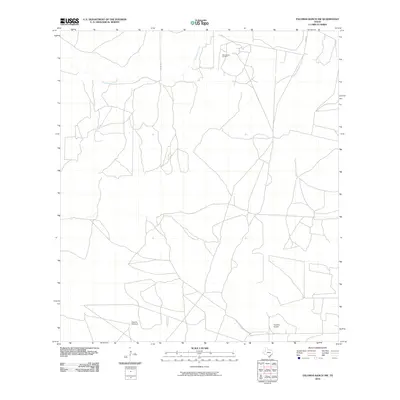
2010 Map of Palomas Ranch NW
USGS Topo · Published 2010About this map
Palo Blanco Oil Field occupies the northern reaches of this Jim Hogg County landscape, indicating the energy industry's footprint in the South Texas brush country. The terrain is defined by a sparse network of ranch roads and county routes, including Co RD 108 and Co RD 107, which connect isolated operational sites. Drainage across this arid expanse is primarily channeled through Palo Blanco Creek, which meanders across the upper section of the map. In the south, aviation and utility infrastructure emerge with the Superior Airport and the Vaquias Windmill, marking essential landmarks for navigation and land management. The map illustrates a working landscape where modern infrastructure supports traditional ranching and petroleum extraction in a remote part of the Rio Grande Plain.
Find a feature on this map
7 named features on this map. Tap any name to fly to it.
Don’t see what you’re looking for? This feature index may not catch every label — zoom into the map to look around manually.
Map Details
Editions of this 2010 Palomas Ranch NW Map
This is the sole edition of this map. No revisions or reprints were ever made.
Other maps of this area

1921 · Falfurrias
USGS Topo · 1:125,000

1956 · Laredo
USGS Topo · 1:250,000

1967 · Hebbronville SE
USGS Topo · 1:24,000

1968 · Palomas Ranch NW
USGS Topo · 1:24,000

1968 · Palomas Ranch SW
USGS Topo · 1:24,000

1968 · Palomas Ranch SE
USGS Topo · 1:24,000

1968 · Palomas Ranch
USGS Topo · 1:24,000
1969 · Laguna Del Toro
USGS Topo · 1:24,000
1969 · Ramirez
USGS Topo · 1:24,000
1972 · Alta Vista Ranch
USGS Topo · 1:24,000