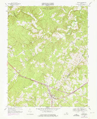
1968 Map of Pamplin
USGS Topo · Published 1976About this map
Pamplin stands as a focal point at the junction of Appomattox Co and Prince Edward Co, where the Norfolk and Western railroad cuts a diagonal path through the Piedmont landscape. The terrain north of the tracks is characterized by the headwaters of the Appomattox River and the extensive wooded reaches of the Appomattox-Buckingham State Forest. Small rural settlements and crossroads like Hixburg and Shields are connected by a network of winding roads, many serving the agricultural and timber interests of the era.
Find a feature on this map
30 named features on this map. Tap any name to fly to it.
Don’t see what you’re looking for? This feature index may not catch every label — zoom into the map to look around manually.
Map Details
Editions of this 1968 Pamplin Map
3 editions found
Other maps of this area

1892 · Appomattox
USGS Topo · 1:125,000

1947 · Roanoke
USGS Topo · 1:250,000

1956 · Brookneal
USGS Topo · 1:62,500

1956 · Charlotte Court House
USGS Topo · 1:62,500

1958 · Appomattox
USGS Topo · 1:62,500

1958 · Pamplin City
USGS Topo · 1:62,500

1959 · Roanoke
USGS Topo · 1:250,000

1963 · Roanoke
USGS Topo · 1:250,000

1967 · Andersonville
USGS Topo · 1:24,000
1967 · Prospect
USGS Topo · 1:24,000