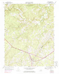
1968 Map of Pamplin
USGS Topo · Published 1985About this map
The Norfolk and Western railway corridor dictates the settlement patterns of this Virginia Piedmont landscape, connecting the community of Pamplin with smaller stops like Shields. The terrain is defined by a dense network of drainage, where the Appomattox River winds through the northern reaches near the Appomattox-Buckingham State Forest. This 1960s survey, with photorevisions from the mid-1970s, documents a rural society centered around small crossroads and country congregations, including Rocks Ch, Walkers Ch, and Pine Ridge Ch. Numerous cemeteries are scattered across the ridges, providing a valuable record for genealogical research in this part of Appomattox and Prince Edward counties. The map also captures infrastructure developments like a major Pipeline and the local Substation, while naming specific geographical points such as Flood and the various branches of Rough Creek, Suanee Creek, and Vaughans Creek.
Find a feature on this map
30 named features on this map. Tap any name to fly to it.
Don’t see what you’re looking for? This feature index may not catch every label — zoom into the map to look around manually.
Map Details
Editions of this 1968 Pamplin Map
3 editions found
Other maps of this area

1892 · Appomattox
USGS Topo · 1:125,000

1947 · Roanoke
USGS Topo · 1:250,000

1956 · Brookneal
USGS Topo · 1:62,500

1956 · Charlotte Court House
USGS Topo · 1:62,500

1958 · Appomattox
USGS Topo · 1:62,500

1958 · Pamplin City
USGS Topo · 1:62,500

1959 · Roanoke
USGS Topo · 1:250,000

1963 · Roanoke
USGS Topo · 1:250,000

1967 · Andersonville
USGS Topo · 1:24,000
1967 · Prospect
USGS Topo · 1:24,000