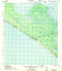
1943 Map of Panama City Beach
USGS Topo · Published 1943About this map
Panama City Beach and the surrounding coastline are documented here in the early 1940s, revealing a landscape of small, nascent beach communities along the Gulf of Mexico. This wartime survey shows concentrated development at Long Beach and Florida Beach, while Betty-Lou Beach sits further west along Route 98. The map highlights the significant geographical contrast between the open Gulf shore and the intricate, marshy northern coastline of West Bay.
Find a feature on this map
14 named features on this map. Tap any name to fly to it.
Don’t see what you’re looking for? This feature index may not catch every label — zoom into the map to look around manually.
Map Details
Editions of this 1943 Panama City Beach Map
3 editions found
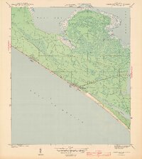
Other maps of this area

1943 · Beacon Beach
USGS Topo · 1:31,680

1943 · Laguna Beach
USGS Topo · 1:31,680

1943 · Panama City
USGS Topo · 1:31,680

1943 · Panama City Beach
USGS Topo · 1:31,680

1943 · Seminole Hills
USGS Topo · 1:24,000

1943 · West Bay
USGS Topo · 1:24,000

1943 · Southport
USGS Topo · 1:24,000

1944 · Southport
USGS Topo · 1:24,000

1944 · Seminole Hills
USGS Topo · 1:31,680

1944 · West Bay
USGS Topo · 1:31,680
Featured Places
- Panama City Beach, FL
- Lower Grand Lagoon, FL
- Biltmore Beach, FL
- Edgewater Gulf Beach, Panama City Beach
- Florida Beach, Panama City Beach