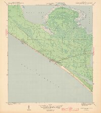
1943 Map of Panama City Beach
USGS Topo · Published 1943About this map
Panama City Beach and its neighboring coastal developments are captured here during World War II, a time when the Gulf Coast shoreline was beginning its transition into a prominent vacation destination. The map shows a relatively sparse layout of coastal settlements, including Betty Lou Beach, Florida Beach, and Long Beach, clustered along the primary road hugging the Gulf of Mexico. Beyond the immediate shore, the landscape quickly gives way to marshy inlets and low-lying wetlands. To the north, the waters of West Bay dominate the view, punctuated by the marshy reaches of Big Johnson Bayou and Bollin Bayou. This 1943 survey, conducted by Lee Morrison and C. I. Hudson for the War Department, documents the early footprint of these beach communities before the post-war building boom significantly altered the topography of Grand Lagoon and the surrounding pine-flat terrain.
Find a feature on this map
11 named features on this map. Tap any name to fly to it.
Don’t see what you’re looking for? This feature index may not catch every label — zoom into the map to look around manually.
Map Details
Editions of this 1943 Panama City Beach Map
3 editions found
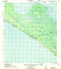
Other maps of this area

1943 · Beacon Beach
USGS Topo · 1:31,680

1943 · Laguna Beach
USGS Topo · 1:31,680

1943 · Panama City
USGS Topo · 1:31,680

1943 · Panama City Beach
USGS Topo · 1:31,680

1943 · Seminole Hills
USGS Topo · 1:24,000

1943 · West Bay
USGS Topo · 1:24,000

1943 · Southport
USGS Topo · 1:24,000

1944 · Southport
USGS Topo · 1:24,000

1944 · Seminole Hills
USGS Topo · 1:31,680

1944 · West Bay
USGS Topo · 1:31,680
Featured Places
- Panama City Beach, FL
- Lower Grand Lagoon, FL
- Biltmore Beach, FL
- Edgewater Gulf Beach, Panama City Beach
- Florida Beach, Panama City Beach