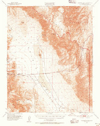
1951 Map of Panamint Butte
USGS Topo · Published 1956About this map
Panamint Valley dominates this mid-century topographic record, showing the stark transition between the Argus Range and the Panamint Range within Death Valley National Monument. The settlement at Panamint Springs serves as a lone hub of activity along Route 190, which cuts eastward toward the high elevation of Towne Pass. The map preserves the paths of early desert commerce and mining, including the historic Old Toll Road, the Nadeau Trail, and the Eichbaum Line.
Find a feature on this map
26 named features on this map. Tap any name to fly to it.
Don’t see what you’re looking for? This feature index may not catch every label — zoom into the map to look around manually.
Map Details
Editions of this 1951 Panamint Butte Map
3 editions found
Other maps of this area

1908 · Ballarat
USGS Topo · 1:250,000

1913 · Ballarat
USGS Topo · 1:250,000

1948 · Death Valley
USGS Topo · 1:250,000

1950 · Darwin
USGS Topo · 1:62,500

1950 · Ubehebe Peak
USGS Topo · 1:62,500

1951 · Darwin
USGS Topo · 1:62,500

1951 · Ubehebe Peak
USGS Topo · 1:62,500

1951 · Panamint Butte
USGS Topo · 1:62,500

1951 · Maturango Peak
USGS Topo · 1:62,500

1951 · Marble Canyon
USGS Topo · 1:62,500