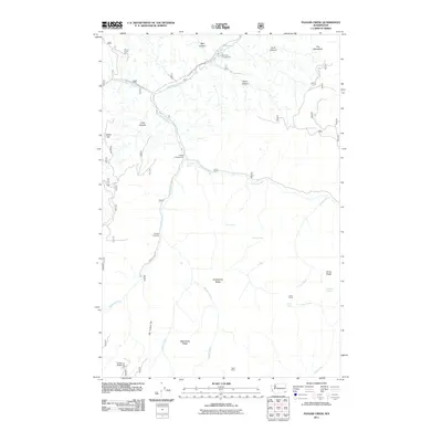
2011 Map of Panjab Creek
USGS Topo · Published 2011About this map
Tucannon River flows through a landscape defined by deep canyons and prominent ridges in this Columbia County region. The map captures a backcountry geography where human activity is centered on established campsites and trail networks, such as Tucannon Campground and Panjab Campground. Notable topographic landmarks like Al Williams Ridge and Horse Ridge dictate the flow of numerous small tributaries, including Cold Creek and Trout Creek. The reliance on natural water sources in this high-elevation terrain is evident from the concentration of named points like Willow Spring, Tucannon Spring, and Bullfrog Spring. Along the southern reaches, the Big Turkey Trail and Panjab Trailhead mark the infrastructure supporting access to the higher slopes of Green Ridge and West Butte Ridge. Isolated landmarks such as Indian Corral and Table Camp suggest long-standing locales for travelers and stockmen moving through the mountain passes.
Find a feature on this map
32 named features on this map. Tap any name to fly to it.
Don’t see what you’re looking for? This feature index may not catch every label — zoom into the map to look around manually.
Map Details
Editions of this 2011 Panjab Creek Map
This is the sole edition of this map. No revisions or reprints were ever made.
Other maps of this area

1937 · Pomeroy
USGS Topo · 1:96,000

1942 · Pomeroy
USGS Topo · 1:125,000

1955 · Pullman
USGS Topo · 1:250,000

1958 · Pullman
USGS Topo · 1:250,000

1967 · Rose Springs
USGS Topo · 1:24,000

1967 · Hopkins Ridge
USGS Topo · 1:24,000

1967 · Cahill Mtn
USGS Topo · 1:24,000

1967 · Oregon Butte
USGS Topo · 1:24,000

1967 · Stentz Spring
USGS Topo · 1:24,000
1967 · Diamond Peak
USGS Topo · 1:24,000