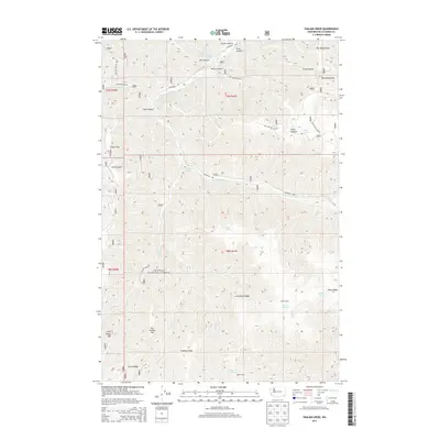
2013 Map of Panjab Creek
USGS Topo · Published 2013About this map
Umatilla National Forest encompasses the majority of this landscape in the southeastern corner of Washington, where the high ridges of the Blue Mountains descend into deep canyons. The Tucannon River flows across the northern portion of the quadrangle, joined by a network of drainage systems including Panjab Cr and Meadow Cr. The terrain is defined by prominent topographical landmarks like Al Williams Ridge, Horse Ridge, and the distinctively named Big Turkey Tail and Little Turkey Tail. Water sources are critical in this high country, evidenced by numerous named springs such as Cascara Spring, Alnus Spring, and Tablecamp Spring near the Table Camp site. The map reflects a region primarily managed for natural resources and recreation, with a sparse network of forest development roads providing access to remote points like Indian Corral and The Wheatfield.
Find a feature on this map
44 named features on this map. Tap any name to fly to it.
Don’t see what you’re looking for? This feature index may not catch every label — zoom into the map to look around manually.
Map Details
Editions of this 2013 Panjab Creek Map
This is the sole edition of this map. No revisions or reprints were ever made.
Other maps of this area

1937 · Pomeroy
USGS Topo · 1:96,000

1942 · Pomeroy
USGS Topo · 1:125,000

1955 · Pullman
USGS Topo · 1:250,000

1958 · Pullman
USGS Topo · 1:250,000

1967 · Rose Springs
USGS Topo · 1:24,000

1967 · Hopkins Ridge
USGS Topo · 1:24,000

1967 · Cahill Mtn
USGS Topo · 1:24,000

1967 · Oregon Butte
USGS Topo · 1:24,000

1967 · Stentz Spring
USGS Topo · 1:24,000
1967 · Diamond Peak
USGS Topo · 1:24,000