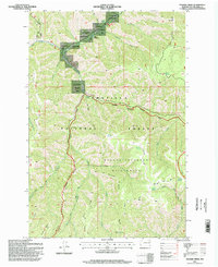
1995 Map of Panjab Creek
USGS Topo · Published 1998About this map
Camp Wooten State Park and the surrounding W T Wooten Wildlife Area define the northern portion of this landscape where the Tucannon River winds through deep canyons. The terrain is characterized by a network of high ridges and narrow creek beds, including Rattlesnake Ridge and Panjab Creek, which flow through the heart of the Umatilla National Forest. Much of the southern half of the map is protected within the Wenaha Tucannon Wilderness, a region where the drainage patterns of Turkey Creek and Meadow Creek converge.
Find a feature on this map
40 named features on this map. Tap any name to fly to it.
Don’t see what you’re looking for? This feature index may not catch every label — zoom into the map to look around manually.
Map Details
Editions of this 1995 Panjab Creek Map
This is the sole edition of this map. No revisions or reprints were ever made.
Other maps of this area

1937 · Pomeroy
USGS Topo · 1:96,000

1942 · Pomeroy
USGS Topo · 1:125,000

1955 · Pullman
USGS Topo · 1:250,000

1958 · Pullman
USGS Topo · 1:250,000

1967 · Rose Springs
USGS Topo · 1:24,000

1967 · Hopkins Ridge
USGS Topo · 1:24,000

1967 · Cahill Mtn
USGS Topo · 1:24,000

1967 · Oregon Butte
USGS Topo · 1:24,000

1967 · Stentz Spring
USGS Topo · 1:24,000
1967 · Diamond Peak
USGS Topo · 1:24,000