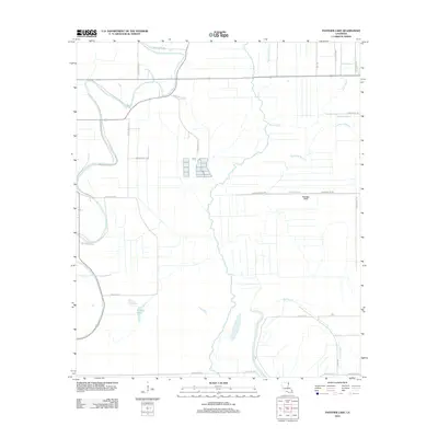
2012 Map of Panther Lake
USGS Topo · Published 2012About this map
Tensas Bayou and Joes Bayou snake through this section of East Carroll Parish, defining a landscape shaped by the complex hydrology of the Mississippi Delta. The 2012 survey illustrates an agricultural region heavily reliant on an intricate network of drainage and irrigation, seen in the path of the Valentine Ditch and the various bayous that crisscross the terrain. Small, family-named landmarks and water bodies provide points of reference for local history, including the curiously named Maiden Doe Bayou and Sassafras Bayou. To the south, Panther Lake sits as a prominent natural feature amidst a grid of rural parish roads. The map captures the persistence of the traditional bayou system alongside modern land management, with features like Graveyard Bayou hinting at the deeper cultural and geographic roots of this Louisiana parish.
Find a feature on this map
34 named features on this map. Tap any name to fly to it.
Don’t see what you’re looking for? This feature index may not catch every label — zoom into the map to look around manually.
Map Details
Editions of this 2012 Panther Lake Map
This is the sole edition of this map. No revisions or reprints were ever made.
Other maps of this area

1909 · Tallulah
USGS Topo · 1:24,000

1935 · Waverly
USGS Topo · 1:62,500

1939 · Talla Bena
USGS Topo · 1:62,500

1939 · Alsatia
USGS Topo · 1:62,500

1955 · Jackson
USGS Topo · 1:250,000

1959 · Mitchiner
USGS Topo · 1:62,500

1961 · Jackson
USGS Topo · 1:250,000

1961 · Waverly
USGS Topo · 1:62,500

1962 · Jackson
USGS Topo · 1:250,000
1963 · Tallulah
USGS Topo · 1:24,000