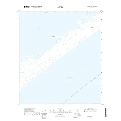
2022 Map of Panther Point
USGS Topo · Published 2022About this map
Matagorda Island stretches across this coastal survey, forming a critical barrier between the open Gulf of Mexico and the intricate estuarine systems of San Antonio Bay. The landscape is dominated by a complex network of shallow water bodies and marshland, including Swan Lake, Cedar Lake, and the clustered Twin Lakes. These interior lakes and secondary points like Cedar Point indicate a dynamic shoreline shaped by tidal action and Gulf currents.
Find a feature on this map
11 named features on this map. Tap any name to fly to it.
Don’t see what you’re looking for? This feature index may not catch every label — zoom into the map to look around manually.
Map Details
Editions of this 2022 Panther Point Map
This is the sole edition of this map. No revisions or reprints were ever made.
Other maps of this area

1952 · Mosquito Point
USGS Topo · 1:24,000

1952 · Long Island
USGS Topo · 1:24,000

1952 · Mesquite Bay
USGS Topo · 1:24,000

1952 · Tivoli SE
USGS Topo · 1:24,000

1952 · Panther Point
USGS Topo · 1:24,000
1952 · Panther Point NE
USGS Topo · 1:24,000

1952 · St. Charles Bay SE
USGS Topo · 1:24,000

1953 · Beeville
USGS Topo · 1:250,000

1956 · Beeville
USGS Topo · 1:250,000

1960 · Beeville
USGS Topo · 1:250,000