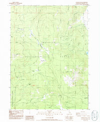
1986 Map of Panther Rock
USGS Topo · Published 1986About this map
Klamath National Forest dominates this mid-1980s terrain in Siskiyou County, where the high mountain geography of the Cascade Range is defined by a complex network of seasonal creeks and high meadows. The upper reaches of the Little Shasta River and Shovel Creek carve through a landscape of prominent peaks, including Panther Rock and Willow Creek Mtn. Human presence is largely tied to forest management and backcountry recreation, evidenced by the Lodgepole Forest Service Station and the remote Kucks Cabin near the northern boundary. The mapping captures a network of forestry roads like Dairy Road and Smith Spring Road that provide access to higher elevations. Points of interest for local history include the Martin Dairy Campground and numerous named water sources such as Little Shasta Spring and Cold Bottle Spring, which have long served as vital stops for those navigating this timbered territory.
Find a feature on this map
40 named features on this map. Tap any name to fly to it.
Don’t see what you’re looking for? This feature index may not catch every label — zoom into the map to look around manually.
Map Details
Editions of this 1986 Panther Rock Map
This is the sole edition of this map. No revisions or reprints were ever made.
Other maps of this area

1886 · Shasta
USGS Topo · 1:250,000

1894 · Shasta
USGS Topo · 1:250,000

1934 · Macdoel
USGS Topo · 1:96,000

1941 · Macdoel
USGS Topo · 1:125,000

1948 · Weed
USGS Topo · 1:250,000

1950 · Weed
USGS Topo · 1:250,000

1954 · The Whaleback
USGS Topo · 1:62,500

1954 · Macdoel
USGS Topo · 1:62,500
1954 · Copco
USGS Topo · 1:62,500
1954 · Dwinnell Reservoir
USGS Topo · 1:62,500