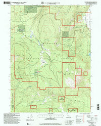
2001 Map of Panther Rock
USGS Topo · Published 2004About this map
Klamath National Forest dominates this northern California terrain, where high-elevation landmarks like Ball Mountain and Panther Rock rise above a landscape defined by volcanic geology and alpine meadows. The map documents a working forest environment at the opening of the 21st century, centered on features like Martin Dairy and the Ball Mountain Lookout. Water sources are densely concentrated throughout the quadrangle, from the headwaters of the Little Shasta River to named pools like Juanita Lake.
Find a feature on this map
36 named features on this map. Tap any name to fly to it.
Don’t see what you’re looking for? This feature index may not catch every label — zoom into the map to look around manually.
Map Details
Editions of this 2001 Panther Rock Map
This is the sole edition of this map. No revisions or reprints were ever made.
Other maps of this area

1886 · Shasta
USGS Topo · 1:250,000

1894 · Shasta
USGS Topo · 1:250,000

1934 · Macdoel
USGS Topo · 1:96,000

1941 · Macdoel
USGS Topo · 1:125,000

1948 · Weed
USGS Topo · 1:250,000

1950 · Weed
USGS Topo · 1:250,000

1954 · The Whaleback
USGS Topo · 1:62,500

1954 · Macdoel
USGS Topo · 1:62,500
1954 · Copco
USGS Topo · 1:62,500
1954 · Dwinnell Reservoir
USGS Topo · 1:62,500