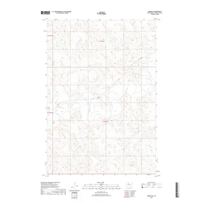
2017 Map of Parade NE
USGS Topo · Published 2017About this map
The Moreau River meanders across this Dewey County landscape, defining the character of the terrain just north of the community of Parade. The river valley is joined by several smaller tributaries, including Goose Creek to the east and Redwater Creek to the west. This area is predominantly rural and agricultural, with most activity concentrated along the transportation corridors that follow the water's path. A key site for local history is the On-a-Tree Cemetery, situated near the center of the sheet just off Bia Rd 2. The network of local roads, such as On The Tree Road and Co Rd 1, indicates a sparse settlement pattern common to this region of South Dakota. The topography is marked by significant elevation changes between the river basin and the surrounding uplands.
Find a feature on this map
13 named features on this map. Tap any name to fly to it.
Don’t see what you’re looking for? This feature index may not catch every label — zoom into the map to look around manually.
Map Details
Editions of this 2017 Parade NE Map
This is the sole edition of this map. No revisions or reprints were ever made.
Other maps of this area

1951 · Ridgeview NW
USGS Topo · 1:24,000

1952 · Whitehorse
USGS Topo · 1:24,000

1952 · Parade NE
USGS Topo · 1:24,000

1952 · Parade NW
USGS Topo · 1:24,000

1953 · McIntosh
USGS Topo · 1:250,000

1958 · McIntosh
USGS Topo · 1:250,000

1978 · Little Moreau Lake
USGS Topo · 1:24,000

1978 · Livermant Lake
USGS Topo · 1:24,000

1981 · Parade SW
USGS Topo · 1:24,000
1981 · Parade
USGS Topo · 1:24,000