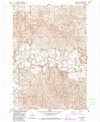
1952 Map of Parade NW
USGS Topo · Published 1987About this map
The confluence of the Moreau River and Green Grass Creek forms a focal point for the settlement at Green Grass, situated within the expansive Cheyenne River Indian Reservation. This 1952 field survey, updated with late-20th-century photorevisions, documents a landscape shaped by the drainage patterns of the Cheyenne River and its northern tributaries. The mapping was conducted as part of the Missouri River Basin development program, capturing the terrain of Dewey County before modern agricultural and infrastructure shifts. Aside from the primary settlement at Green Grass, the map identifies local industrial activity such as a Gravel Pit near the riverbanks, alongside natural watercourses like Redwater Creek and Meadow Creek. The detailed topography illustrates the intricate coulees and bluffs typical of the western South Dakota plains, providing a clear record of the area's geography during the mid-century era.
Find a feature on this map
9 named features on this map. Tap any name to fly to it.
Don’t see what you’re looking for? This feature index may not catch every label — zoom into the map to look around manually.
Map Details
Editions of this 1952 Parade NW Map
2 editions found
Other maps of this area

1952 · Parade NE
USGS Topo · 1:24,000

1952 · Lantry NE
USGS Topo · 1:24,000

1952 · Parade NW
USGS Topo · 1:24,000

1953 · McIntosh
USGS Topo · 1:250,000

1958 · McIntosh
USGS Topo · 1:250,000

1978 · Peach Lake
USGS Topo · 1:24,000

1978 · Little Moreau Lake
USGS Topo · 1:24,000

1978 · Livermant Lake
USGS Topo · 1:24,000

1981 · Parade SW
USGS Topo · 1:24,000
1981 · Parade
USGS Topo · 1:24,000