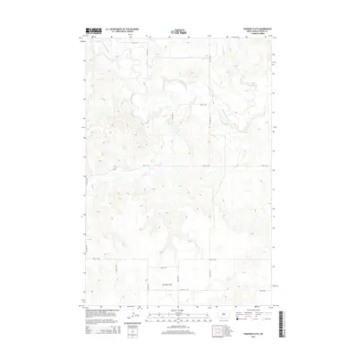
2014 Map of Paradise Flats
USGS Topo · Published 2014About this map
The wide, elevated plateau of Paradise Flats dominates the southern landscape of this Grant County region, offering a clear view of the high plains topography. The Cannonball River meanders across the northern portion of the map, its winding course defining the drainage patterns of the area. Several tributaries, including Snake Cr and Boxelder Cr, cut through the terrain, creating a network of coulees and draws that contrast with the flat uplands. The section-line road system, including 60th Ave SW and 81st St SW, reveals the enduring influence of the Public Land Survey System on modern North Dakota transit and land management.
Find a feature on this map
14 named features on this map. Tap any name to fly to it.
Don’t see what you’re looking for? This feature index may not catch every label — zoom into the map to look around manually.
Map Details
Editions of this 2014 Paradise Flats Map
This is the sole edition of this map. No revisions or reprints were ever made.
Other maps of this area

1954 · Bismarck
USGS Topo · 1:250,000

1958 · Bismarck
USGS Topo · 1:250,000

1971 · Lookout Butte
USGS Topo · 1:24,000

1972 · Carson SE
USGS Topo · 1:24,000

1972 · Leith
USGS Topo · 1:24,000

1972 · Paradise Flats
USGS Topo · 1:24,000

1972 · Wheeler Hills
USGS Topo · 1:24,000
1972 · Pitt Creek
USGS Topo · 1:24,000
1972 · Parks Hills
USGS Topo · 1:24,000

1980 · Brisbane
USGS Topo · 1:24,000