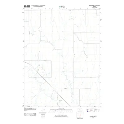
2010 Map of Paradise NW
USGS Topo · Published 2010About this map
Eagle Creek and Paradise Creek define the drainage patterns of this rural landscape in Osborne County, Kansas. The map captures a transition toward modernized road infrastructure while preserving long-standing landmarks of the local community. Significant genealogy sites include the Ixl Cemetery in the north and the Mount Herman Cemetery to the south, both serving as central points for local history research. The terrain is crisscrossed by a grid of agricultural routes such as S 280th Ave and W 275th Dr, illustrating the structured land division typical of the Great Plains. These roads connect isolated farmsteads and rural holdings, providing a clear view of the area's late 20th-century development before further consolidation.
Find a feature on this map
16 named features on this map. Tap any name to fly to it.
Don’t see what you’re looking for? This feature index may not catch every label — zoom into the map to look around manually.
Map Details
Editions of this 2010 Paradise NW Map
This is the sole edition of this map. No revisions or reprints were ever made.
Other maps of this area

1896 · Osborne
USGS Topo · 1:125,000

1896 · Plainville
USGS Topo · 1:125,000

1955 · Beloit
USGS Topo · 1:250,000

1959 · Beloit
USGS Topo · 1:250,000
1978 · Natoma
USGS Topo · 1:24,000
1978 · Paradise NW
USGS Topo · 1:24,000
1978 · Paradise
USGS Topo · 1:24,000
1978 · Alton SW
USGS Topo · 1:24,000
1978 · Fairport
USGS Topo · 1:24,000
1978 · Waldo
USGS Topo · 1:24,000