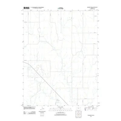
2012 Map of Paradise NW
USGS Topo · Published 2012About this map
Paradise Cr and Eagle Cr wind through this rural section of Osborne County, defining the drainage patterns of a landscape marked by a strict sectional road grid. The geography is punctuated by small, significant local landmarks like Mount Herman Cem in the south and IXL Cem near the northern boundary. These burial grounds serve as primary points of historical reference in an otherwise agricultural expanse. Transportation is managed through a network of county routes, including Co Hwy-404 and N Co Line Rd, which align with the straight-line property boundaries characteristic of the Great Plains. The map captures a moment of modern rural continuity, where the naming of remote intersections like W 265th Dr and S 270th Ave provides specific coordinates for genealogists tracing family land holdings in central Kansas.
Find a feature on this map
20 named features on this map. Tap any name to fly to it.
Don’t see what you’re looking for? This feature index may not catch every label — zoom into the map to look around manually.
Map Details
Editions of this 2012 Paradise NW Map
This is the sole edition of this map. No revisions or reprints were ever made.
Other maps of this area

1896 · Osborne
USGS Topo · 1:125,000

1896 · Plainville
USGS Topo · 1:125,000

1955 · Beloit
USGS Topo · 1:250,000

1959 · Beloit
USGS Topo · 1:250,000
1978 · Natoma
USGS Topo · 1:24,000
1978 · Paradise NW
USGS Topo · 1:24,000
1978 · Paradise
USGS Topo · 1:24,000
1978 · Alton SW
USGS Topo · 1:24,000
1978 · Fairport
USGS Topo · 1:24,000
1978 · Waldo
USGS Topo · 1:24,000