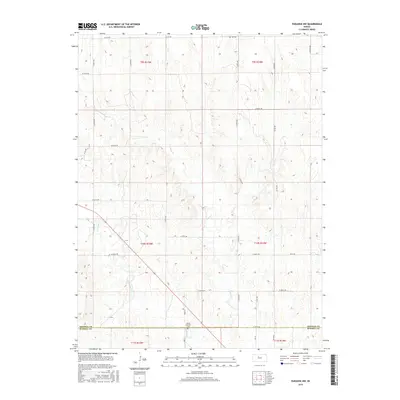
2015 Map of Paradise NW
USGS Topo · Published 2015About this map
The rolling plains of north-central Kansas are defined here by the winding drainage of Eagle Cr and Paradise Cr, which carve through the agricultural landscape. This survey of the rural uplands reflects the sparse, grid-based settlement pattern typical of the region, where section lines are marked by unpaved corridors like W 240th Dr and W 275th Dr. At the southern edge of the sheet, the boundary between Osborne and Russell counties is clearly delineated along W 300th Dr. For those interested in local history, the map identifies two isolated burial grounds: IXL Cem in the northeast and Mount Herman Cem in the south, both serving as quiet landmarks of the area's early farming families and small rural communities.
Find a feature on this map
21 named features on this map. Tap any name to fly to it.
Don’t see what you’re looking for? This feature index may not catch every label — zoom into the map to look around manually.
Map Details
Editions of this 2015 Paradise NW Map
This is the sole edition of this map. No revisions or reprints were ever made.
Other maps of this area

1896 · Osborne
USGS Topo · 1:125,000

1896 · Plainville
USGS Topo · 1:125,000

1955 · Beloit
USGS Topo · 1:250,000

1959 · Beloit
USGS Topo · 1:250,000
1978 · Natoma
USGS Topo · 1:24,000
1978 · Paradise NW
USGS Topo · 1:24,000
1978 · Paradise
USGS Topo · 1:24,000
1978 · Alton SW
USGS Topo · 1:24,000
1978 · Fairport
USGS Topo · 1:24,000
1978 · Waldo
USGS Topo · 1:24,000