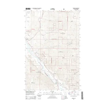
2014 Map of Paradise
USGS Topo · Published 2014About this map
The settlement of Paradise sits at a strategic bend where the Clark Fork river meets the steep slopes of the Coeur d'Alene Mountains. This 2014 survey documents the rugged geography of the Lolo National Forest, where the landscape is defined by dramatic elevation changes at Deemer Peak and Henry Peak. The map reveals a network of mountain drainages, including Paradise Gulch and Hugo Canyon, which feed into the valley floor. Transportation patterns are clearly established here, with MT-200 following the river corridor while local routes like Boehler Ranch Dr and Deemer Creek Rd provide access into the timbered uplands. Notable local landmarks include the Paradise Cem and the distinctive wetland of Smiley Slough, illustrating the intersection of human settlement and the complex hydrography of the northern Rockies.
Find a feature on this map
50 named features on this map. Tap any name to fly to it.
Don’t see what you’re looking for? This feature index may not catch every label — zoom into the map to look around manually.
Map Details
Editions of this 2014 Paradise Map
This is the sole edition of this map. No revisions or reprints were ever made.
Other maps of this area

1956 · Wallace
USGS Topo · 1:250,000

1959 · Perma
USGS Topo · 1:62,500

1959 · Plains
USGS Topo · 1:62,500

1960 · Wallace
USGS Topo · 1:250,000

1964 · Baldy Lake
USGS Topo · 1:24,000

1964 · Weeksville
USGS Topo · 1:24,000

1964 · Hot Springs
USGS Topo · 1:24,000
1980 · Polson
USGS Topo · 1:100,000
1984 · Paradise
USGS Topo · 1:24,000
1984 · Sunrise Spring
USGS Topo · 1:24,000