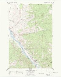
1989 Map of Paradise
USGS Topo · Published 1989About this map
Paradise occupies a narrow strip of land along the winding Clark Fork river, serving as a localized hub for the Burlington Northern railroad. This 1989 survey, prepared for the Bureau of Indian Affairs, details the interface between the Flathead Indian Res and the Lolo National Forest. The geography is defined by steep drainages like Paradise Gulch and Boyer Creek that feed into the river valley. The map documents industrial and infrastructure elements vital to the local economy, including several Gravel Pits, a Gaging Sta on the river, and multiple water tanks positioned near the rail lines. Notable landmarks such as Deemer Peak and Henry Peak anchor the high ground, while the local Cem and various bench marks provide specific points of interest for genealogists and surveyors tracking the development of this river corridor.
Find a feature on this map
28 named features on this map. Tap any name to fly to it.
Don’t see what you’re looking for? This feature index may not catch every label — zoom into the map to look around manually.
Map Details
Editions of this 1989 Paradise Map
This is the sole edition of this map. No revisions or reprints were ever made.
Other maps of this area

1956 · Wallace
USGS Topo · 1:250,000

1959 · Perma
USGS Topo · 1:62,500

1959 · Plains
USGS Topo · 1:62,500

1960 · Wallace
USGS Topo · 1:250,000

1964 · Baldy Lake
USGS Topo · 1:24,000

1964 · Weeksville
USGS Topo · 1:24,000

1964 · Hot Springs
USGS Topo · 1:24,000
1980 · Polson
USGS Topo · 1:100,000
1984 · Paradise
USGS Topo · 1:24,000
1984 · Sunrise Spring
USGS Topo · 1:24,000