
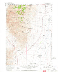
1958 Map of Paradise Valley
USGS Topo · Published 1960About this map
Paradise Valley serves as the primary hub in this Nevada basin, where the high peaks of the Humboldt National Forest drop into a valley floor defined by ranching and old transportation corridors. The western portion of the sheet is dominated by the Santa Rosa Range, reaching its peak at Paradise Pk, while the lowlands are crosscut by Martin Creek and Little Humboldt River. Historically significant stage stops like Willow Point and Paradise Well mark the arid valley floor, tracing a route through the basin that predated modern highways. The distribution of family-named holdings, such as the Ferraro Ranch and Marie Miller Ranch, suggests a long-established agricultural community dependent on the drainage from the mountains. Scattered prospects, ore mills, and shafts near Andorno Creek and Stone House point to the area's mineral exploration history, juxtaposed against the vast ranching operations in the eastern flats.
Find a feature on this map
61 named features on this map. Tap any name to fly to it.
Don’t see what you’re looking for? This feature index may not catch every label — zoom into the map to look around manually.
Map Details
Editions of this 1958 Paradise Valley Map
2 editions found
Other maps of this area

1882 · Paradise
USGS Topo · 1:250,000

1893 · Paradise
USGS Topo · 1:250,000

1945 · Osgood Mountains
USGS Topo · 1:62,500

1945 · Hot Springs
USGS Topo · 1:62,500

1947 · Osgood Mountains
USGS Topo · 1:62,500

1947 · Hot Springs Peak
USGS Topo · 1:62,500

1955 · McDermitt
USGS Topo · 1:250,000

1958 · Awakening Peak
USGS Topo · 1:62,500

1959 · McDermitt
USGS Topo · 1:250,000

1959 · Bliss
USGS Topo · 1:62,500