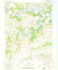
1972 Map of Paris East
USGS Topo · Published 1974About this map
The Middle Fork Salt River, Elk Fork Salt River, and South Fork Salt River converge in this section of Monroe County, just as the Clarence Cannon Reservoir began to reshape the landscape. At the western edge, the town of Paris serves as a focal point, with the Norfolk and Western railroad corridor passing through the river valleys. The survey captures a moment of transition where traditional land use meets large-scale water management projects.
Find a feature on this map
36 named features on this map. Tap any name to fly to it.
Don’t see what you’re looking for? This feature index may not catch every label — zoom into the map to look around manually.
Map Details
Editions of this 1972 Paris East Map
This is the sole edition of this map. No revisions or reprints were ever made.
Other maps of this area

1890 · Mexico
USGS Topo · 1:125,000

1890 · Moberly
USGS Topo · 1:125,000

1903 · Palmyra
USGS Topo · 1:125,000
1945 · Florida
USGS Topo · 1:62,500

1948 · Quincy
USGS Topo · 1:250,000

1953 · Moberly
USGS Topo · 1:250,000

1954 · Moberly
USGS Topo · 1:250,000

1956 · Quincy
USGS Topo · 1:250,000

1957 · Moberly
USGS Topo · 1:250,000

1960 · Moberly
USGS Topo · 1:250,000