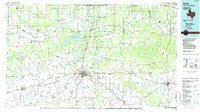
1985 Map of Paris
USGS Topo · Published 1985About this map
The Red River serves as the winding boundary between Texas and Oklahoma, anchoring a landscape where the river’s oxbows and sloughs contrast with the geometric grid of the Red River Valley’s agriculture. This mid-1980s documentation of Paris and Lamar Point shows the region as a significant transportation and military hub. The northern extent is dominated by the Camp Maxey military installation and the expansive Pat Mayse Lake, while the city of Paris serves as a focal point for the Missouri Pacific and Atchison Topeka and Santa Fe railroads. Smaller communities like Honey Grove, Roxton, and Clarksville are interspersed with local landmarks such as Paris Junior College and various rural cornerstones like Allens Chapel Cem and Forest Hill Ch. The map provides a look at the transition from the upland woods to the fertile bottomlands near Raymond Gary State Recreation Area.
Find a feature on this map
145 named features on this map. Tap any name to fly to it.
Don’t see what you’re looking for? This feature index may not catch every label — zoom into the map to look around manually.
Map Details
Editions of this 1985 Paris Map
This is the sole edition of this map. No revisions or reprints were ever made.
Other maps of this area

1899 · Atoka
USGS Topo · 1:125,000

1900 · Atoka
USGS Topo · 1:125,000

1901 · Antlers
USGS Topo · 1:125,000

1901 · Alikchi
USGS Topo · 1:125,000

1902 · Lukfata
USGS Topo · 1:125,000

1903 · Paris
USGS Topo · 1:125,000

1912 · Antlers
USGS Topo · 1:125,000

1925 · Antlers
USGS Topo · 1:125,000

1947 · Honey Grove
USGS Topo · 1:62,500

1948 · Grant
USGS Topo · 1:62,500