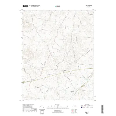
2019 Map of Park
USGS Topo · Published 2019About this map
Seymour and Bear Wallow anchor this rural landscape in central Kentucky, where the boundaries of Hart, Barren, and Metcalfe counties converge. The topography is defined by prominent rises such as Dawson Knob, Wootens Knob, and Vaughn Knob, overlooking a network of local thoroughfares including Lonoke Rd and Rex Rd. Small settlements like Uno and LeGrande illustrate the long-standing agricultural pattern of the region, connected by historic routes that follow the natural contours of Wallow Ridge. Hydrological features such as Blue Spring Cr and the Drury Roberts Spring provide evidence of the area's karst-influenced drainage. The inclusion of the Natchez Trace Farm Airport near the southern border highlights modern aviation infrastructure integrated into this traditional farming landscape.
Find a feature on this map
65 named features on this map. Tap any name to fly to it.
Don’t see what you’re looking for? This feature index may not catch every label — zoom into the map to look around manually.
Map Details
Editions of this 2019 Park Map
This is the sole edition of this map. No revisions or reprints were ever made.
Other maps of this area

1934 · Munfordville
USGS Topo · 1:48,000

1935 · Horse Cave
USGS Topo · 1:48,000

1937 · Munfordville
USGS Topo · 1:62,500

1938 · Horse Cave
USGS Topo · 1:62,500

1953 · Sulphur Well
USGS Topo · 1:24,000

1953 · Hudgins
USGS Topo · 1:24,000

1953 · Munfordville
USGS Topo · 1:24,000

1953 · Center
USGS Topo · 1:24,000
1953 · Canmer
USGS Topo · 1:24,000

1954 · Park
USGS Topo · 1:24,000