
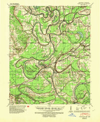
1939 Map of Park Place
USGS Topo · Published 1941About this map
The St Francis River and the L'Anguille River dominate this delta landscape at the edge of Crowleys Ridge. This era shows a densely settled agricultural region defined by a intricate system of drainage bayous and river bends, where transportation relied on the Missouri Pacific and Arkansas & Mississippi railroads alongside river crossings like Robinson Ferry. Local social life centered on numerous combined institutions such as True Love Bar Ch & Sch and Pleasant Grove Ch & Sch.
Find a feature on this map
113 named features on this map. Tap any name to fly to it.
Don’t see what you’re looking for? This feature index may not catch every label — zoom into the map to look around manually.
Map Details
Editions of this 1939 Park Place Map
2 editions found
Other maps of this area

1931 · Horseshoe Lake
USGS Topo · 1:62,500

1939 · Clayton
USGS Topo · 1:62,500

1939 · Horseshoe Lake
USGS Topo · 1:62,500

1939 · Wynne
USGS Topo · 1:62,500

1939 · Edmondson
USGS Topo · 1:62,500

1939 · Latour
USGS Topo · 1:62,500

1940 · Marvell
USGS Topo · 1:62,500

1940 · Whitmore
USGS Topo · 1:62,500

1940 · Marianna
USGS Topo · 1:62,500

1948 · Helena
USGS Topo · 1:250,000