1959 Map of Parker Dam
USGS Topo · Published 1960About this map
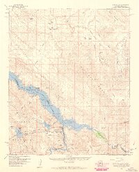
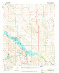
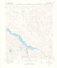
Lake Havasu dominates this mid-century desert landscape, serving as a critical reservoir managed within the Havasu Lake National Wildlife Refuge. The map details the massive water engineering of the era, centered on Parker Dam and the Whitset Intake, which marks the beginning of the Colorado River Aqueduct system. Nearby industrial and infrastructure features include the Gene Pumping Sta and various siphons and tunnels that move water through the Whipple Mountains.
Find a feature on this map
72 named features on this map. Tap any name to fly to it.
Don’t see what you’re looking for? This feature index may not catch every label — zoom into the map to look around manually.
Map Details
Editions of this 1959 Parker Dam Map
3 editions found
Other maps of this area

1903 · Needles
USGS Topo · 1:125,000

1904 · Needles Special
USGS Topo · 1:125,000

1911 · Parker
USGS Topo · 1:125,000

1923 · Signal
USGS Topo · 1:250,000

1927 · Buck Mountains
USGS Topo · 1:62,500

1929 · Buck Mountains
USGS Topo · 1:62,500

1942 · Signal
USGS Topo · 1:250,000

1943 · Giers Basin
USGS Topo · 1:62,500

1943 · Topock
USGS Topo · 1:62,500

1943 · Whipple Mts.
USGS Topo · 1:62,500