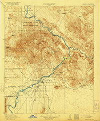
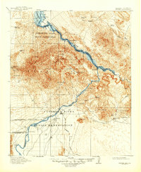
1911 Map of Parker
USGS Topo · Published 1921About this map
The Colorado River serves as the central artery for this early 20th-century borderlands survey, defining the boundary between Arizona and California. The settlement at Parker sits at the junction of the Santa Fe Prescott and Phoenix RR and the river, near the Agency and the southern reaches of the Chemehuevi Valley Indian Reservation. The landscape is a mix of alluvial flats and high desert peaks, where the presence of numerous landings like Eagle Landing, Doyles Landing, and Liverpool Landing highlights the river's role as a primary transportation corridor before the era of major dams.
Find a feature on this map
53 named features on this map. Tap any name to fly to it.
Don’t see what you’re looking for? This feature index may not catch every label — zoom into the map to look around manually.
Map Details
Editions of this 1911 Parker Map
3 editions found
Other maps of this area

1903 · Needles
USGS Topo · 1:125,000

1904 · Needles Special
USGS Topo · 1:125,000

1911 · Parker
USGS Topo · 1:125,000

1923 · Signal
USGS Topo · 1:250,000

1927 · Buck Mountains
USGS Topo · 1:62,500

1929 · Buck Mountains
USGS Topo · 1:62,500

1930 · Linskey
USGS Topo · 1:62,500

1931 · Moon Mtn
USGS Topo · 1:62,500

1932 · Moon Mtn
USGS Topo · 1:62,500

1942 · Signal
USGS Topo · 1:250,000