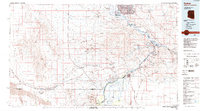
1985 Map of Parker
USGS Topo · Published 1985About this map
The Colorado River serves as the central artery for this desert landscape, defining the border between Arizona and California. Upstream from Parker, the river is backed up behind the Parker Dam to form Lake Havasu, a critical water resource that supports the Colorado River Aqueduct heading west. The region is heavily marked by industrial and mining history, with a high concentration of claims including the Alice Mine, Jacklin Mine, and California Mine scattered across the Whipple Mountains and Buckskin Mountains. Transportation networks are anchored by the Atchison Topeka and Santa Fe railroad, which skirts the southern edge of the Turtle Mountains. Large tracts of land are managed through the Chemehuevi Indian Reservation and Colorado River Indian Reservation, reflecting the complex jurisdictional nature of the river valley during the mid-1980s.
Find a feature on this map
88 named features on this map. Tap any name to fly to it.
Don’t see what you’re looking for? This feature index may not catch every label — zoom into the map to look around manually.
Map Details
Editions of this 1985 Parker Map
2 editions found
Other maps of this area

1903 · Needles
USGS Topo · 1:125,000

1904 · Needles Special
USGS Topo · 1:125,000

1911 · Parker
USGS Topo · 1:125,000

1923 · Signal
USGS Topo · 1:250,000

1927 · Buck Mountains
USGS Topo · 1:62,500

1929 · Buck Mountains
USGS Topo · 1:62,500

1930 · Linskey
USGS Topo · 1:62,500

1931 · Moon Mtn
USGS Topo · 1:62,500

1932 · Moon Mtn
USGS Topo · 1:62,500

1942 · Signal
USGS Topo · 1:250,000