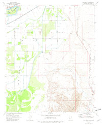
1970 Map of Parker SE
USGS Topo · Published 1982About this map
Colorado River waters define the western edge of this landscape, where the Island sits on the border of California and Arizona. The Parker Valley is dominated by a systematic irrigation network including the Main Canal, Drain No 4, and Drain No 5, which supports a grid of agricultural roads such as Booth Road and Burns Road. This managed landscape contrasts sharply with the eastern terrain, where the Atchison Topeka and Santa Fe railroad skirts the foothills of Mesquite Mountain.
Find a feature on this map
31 named features on this map. Tap any name to fly to it.
Don’t see what you’re looking for? This feature index may not catch every label — zoom into the map to look around manually.
Map Details
Editions of this 1970 Parker SE Map
2 editions found
Other maps of this area

1911 · Parker
USGS Topo · 1:125,000

1930 · Linskey
USGS Topo · 1:62,500

1931 · Moon Mtn
USGS Topo · 1:62,500

1932 · Moon Mtn
USGS Topo · 1:62,500

1942 · Blythe
USGS Topo · 1:250,000

1942 · MOON MTN
USGS Topo · 1:62,500

1943 · Parker
USGS Topo · 1:62,500

1949 · Parker
USGS Topo · 1:62,500

1950 · Parker
USGS Topo · 1:62,500

1954 · Salton Sea
USGS Topo · 1:250,000