1898 Map of Parker
USGS Topo · Published 1949About this map
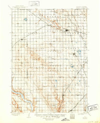
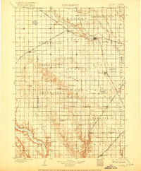
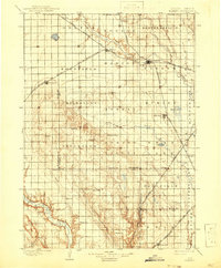
The East Fork Vermillion River and West Fork Vermillion River converge near the growing railroad junction of Parker, which serves as a central hub for the surrounding agricultural prairie. Surveyed in the late nineteenth century, this landscape is defined by a dense grid of early townships and the expansion of three major rail lines. The Chicago Milwaukee and St Paul railroad cuts diagonally across the northern townships, anchoring settlements like Marion and Freeman. To the south, the prominent elevation of Turkey Ridge divides the drainage of Turkey Ridge Creek from the James River valley in the southwest corner. Local history is preserved in the placement of small rural communities such as Center Point, Idylwilde, and Ourtown, many of which were vital local centers before the consolidation of the region's transport networks.
Find a feature on this map
58 named features on this map. Tap any name to fly to it.
Don’t see what you’re looking for? This feature index may not catch every label — zoom into the map to look around manually.
Map Details
Editions of this 1898 Parker Map
4 editions found
Other maps of this area

1897 · Canton
USGS Topo · 1:125,000

1898 · Olivet
USGS Topo · 1:125,000

1898 · Parker
USGS Topo · 1:125,000

1898 · Elk Point
USGS Topo · 1:125,000

1899 · Alexandria
USGS Topo · 1:125,000

1900 · Canton
USGS Topo · 1:125,000

1901 · Elk Point
USGS Topo · 1:125,000

1907 · Elk Point
USGS Topo · 1:125,000

1955 · Sioux City
USGS Topo · 1:250,000

1955 · Sioux Falls
USGS Topo · 1:250,000