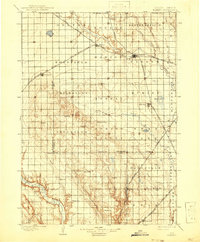
1898 Map of Parker
USGS Topo · Published 1941About this map
The East Fork Vermillion River and West Fork Vermillion River converge near Parker in this late nineteenth-century portrait of Turner County. This landscape is defined by the early development of the Chicago Milwaukee and St Paul railroad, which spurred the growth of towns like Marion, Freeman, and Dolton along its tracks. To the south, the prominent elevation of Turkey Ridge rises above the surrounding plains, influencing the settlement patterns of townships such as Spring Valley and Idylwilde. The map captures a transition era for southeastern South Dakota, showing numerous small prairie settlements and post offices like Ady-Wilde, Mayfield, and Marindahl, many of which were central to the lives of early homesteaders. The presence of Swan Lake and Mud Lake provides a reference for the natural hydrology before extensive modern drainage altered the region's character.
Find a feature on this map
54 named features on this map. Tap any name to fly to it.
Don’t see what you’re looking for? This feature index may not catch every label — zoom into the map to look around manually.
Map Details
Editions of this 1898 Parker Map
4 editions found
Other maps of this area

1897 · Canton
USGS Topo · 1:125,000

1898 · Olivet
USGS Topo · 1:125,000

1898 · Parker
USGS Topo · 1:125,000

1898 · Elk Point
USGS Topo · 1:125,000

1899 · Alexandria
USGS Topo · 1:125,000

1900 · Canton
USGS Topo · 1:125,000

1901 · Elk Point
USGS Topo · 1:125,000

1907 · Elk Point
USGS Topo · 1:125,000

1955 · Sioux City
USGS Topo · 1:250,000

1955 · Sioux Falls
USGS Topo · 1:250,000