
1902 Map of Parkersburg
USGS Topo · Published 1902About this map
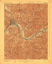
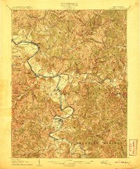
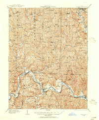
The confluence of the Little Kanawha River and the Ohio River centers this 1902 survey, illustrating the industrial and transport hub of Parkersburg. The map captures a critical period of riverfront development and rail expansion, with the Baltimore and Ohio R. R. tracing the shorelines of both Ohio and West Virginia. On the Ohio side, the Muskingum River flows into the valley, supporting a network of riverside settlements like Belpre and Rockland.
Find a feature on this map
78 named features on this map. Tap any name to fly to it.
Don’t see what you’re looking for? This feature index may not catch every label — zoom into the map to look around manually.
Map Details
Editions of this 1902 Parkersburg Map
This is the sole edition of this map. No revisions or reprints were ever made.
Other maps of this area

1903 · Macksburg
USGS Topo · 1:62,500

1904 · Parkersburg
USGS Topo · 1:62,500
1904 · Marietta
USGS Topo · 1:62,500

1904 · Chesterhill
USGS Topo · 1:62,500

1905 · Macksburg
USGS Topo · 1:62,500
1906 · Elizabeth
USGS Topo · 1:62,500

1906 · Belleville
USGS Topo · 1:62,500

1906 · Chesterhill
USGS Topo · 1:62,500

1907 · Keno
USGS Topo · 1:62,500
1909 · Caldwell
USGS Topo · 1:62,500