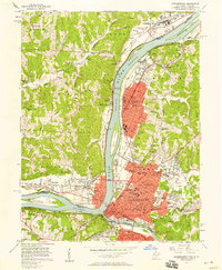
1957 Map of Parkersburg
USGS Topo · Published 1958About this map
Parkersburg and its neighboring riverfront towns are documented here in the mid-1950s, a period of significant post-war industrial and suburban expansion along the Ohio River. The convergence of the Little Kanawha River and the Ohio serves as the primary anchor for the region's development, with Parkersburg and Belpre facing each other across the state line. Detailed street grids and named avenues like Grand Central Avenue and Murdoch Ave indicate the growing density of Vienna and the central urban core.
Find a feature on this map
117 named features on this map. Tap any name to fly to it.
Don’t see what you’re looking for? This feature index may not catch every label — zoom into the map to look around manually.
Map Details
Editions of this 1957 Parkersburg Map
This is the sole edition of this map. No revisions or reprints were ever made.
Other maps of this area

1902 · Parkersburg
USGS Topo · 1:62,500

1904 · Parkersburg
USGS Topo · 1:62,500

1904 · Marietta
USGS Topo · 1:62,500

1906 · Elizabeth
USGS Topo · 1:62,500

1906 · Belleville
USGS Topo · 1:62,500

1924 · Belleville
USGS Topo · 1:62,500

1924 · Marietta
USGS Topo · 1:62,500

1924 · Elizabeth
USGS Topo · 1:62,500

1926 · Elizabeth
USGS Topo · 1:62,500

1926 · Belleville
USGS Topo · 1:62,500