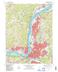
1994 Map of Parkersburg
USGS Topo · Published 1998About this map
The Ohio River serves as the central artery for this mid-1990s portrait of the West Virginia-Ohio border, where the industrial and residential centers of Parkersburg and Vienna meet the eastern bank. The landscape is defined by its riparian geometry, featuring the elongated Neal Island and the grounds of Blennerhassett Island Historic State Park. Across the water, the Ohio settlements of Belpre and Rockland are connected by bridge networks and the Baltimore and Ohio RR, which traces the river's path. This survey captures a highly developed corridor anchored by regional institutions like St Josephs Hospital and Ohio Valley College. Away from the urban centers, the terrain transitions into the ridge-and-valley patterns of Barlow and Warren townships, where scattered landmarks like Barnetts Ridge Ch and Cutler Chapel indicate a more dispersed rural layout that has persisted alongside the river's heavy industrial activity.
Find a feature on this map
98 named features on this map. Tap any name to fly to it.
Don’t see what you’re looking for? This feature index may not catch every label — zoom into the map to look around manually.
Map Details
Editions of this 1994 Parkersburg Map
This is the sole edition of this map. No revisions or reprints were ever made.
Other maps of this area

1902 · Parkersburg
USGS Topo · 1:62,500

1904 · Parkersburg
USGS Topo · 1:62,500

1904 · Marietta
USGS Topo · 1:62,500

1906 · Elizabeth
USGS Topo · 1:62,500

1906 · Belleville
USGS Topo · 1:62,500

1924 · Belleville
USGS Topo · 1:62,500

1924 · Marietta
USGS Topo · 1:62,500

1924 · Elizabeth
USGS Topo · 1:62,500

1926 · Elizabeth
USGS Topo · 1:62,500

1926 · Belleville
USGS Topo · 1:62,500