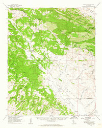
1961 Map of Parkfield
USGS Topo · Published 1962About this map
Parkfield serves as the central hub of this rugged Central Coast interior, situated where the Cholame Valley meets the foothills of Middle Mountain. The 1961 landscape is defined by its complex geology and scattered human outposts, featuring a network of isolated homesteads and mining sites like the Patriquin Mine and Kings Mine in the northern heights near Mustang Peak. Ranching life is evident through landmarks such as the Heg Ranch, Cholame Ranch, and the remains at Riley Cabin.
Find a feature on this map
94 named features on this map. Tap any name to fly to it.
Don’t see what you’re looking for? This feature index may not catch every label — zoom into the map to look around manually.
Map Details
Editions of this 1961 Parkfield Map
2 editions found

Other maps of this area

1912 · Coalinga
USGS Topo · 1:125,000

1914 · Cholame
USGS Topo · 1:125,000

1915 · Priest Valley
USGS Topo · 1:125,000

1915 · Cholame
USGS Topo · 1:125,000

1917 · Cholame
USGS Topo · 1:125,000

1919 · San Miguel
USGS Topo · 1:62,500

1919 · Paso Robles
USGS Topo · 1:62,500

1930 · Canoas Creek
USGS Topo · 1:31,680
1934 · The Dark Hole
USGS Topo · 1:31,680

1934 · Reef Ridge
USGS Topo · 1:31,680