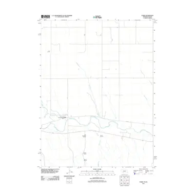
2011 Map of Parks
USGS Topo · Published 2011About this map
Parks and its surrounding river valley dominate this Nebraska-Kansas border landscape, where the Republican River flows eastward across the southern portion of the quadrangle. The settlement's civic center is marked by the Parks Post Office and the residential grid defined by Ewing St, while the Parks Cemetery sits on higher ground to the northwest. This 2011 survey reveals a deeply dissected terrain south of the river, where a series of named drainages including Will Stanford Canyon, Jarvis Canyon, Barlett Canyon, and Smutz Canyon cut through the plains. To the north, the hydrology is characterized by long, winding tributaries like Horse Creek and Rock Creek, illustrating a landscape shaped by significant water erosion. The road network, including Doane Rd, reflects the rectilinear section-line grid typical of the Great Plains, providing access to these isolated canyon features and rural farmsteads.
Find a feature on this map
15 named features on this map. Tap any name to fly to it.
Don’t see what you’re looking for? This feature index may not catch every label — zoom into the map to look around manually.
Map Details
Editions of this 2011 Parks Map
This is the sole edition of this map. No revisions or reprints were ever made.
Other maps of this area

1942 · St. Francis
USGS Topo · 1:62,500

1943 · St. Francis
USGS Topo · 1:62,500

1951 · St Francis
USGS Topo · 1:62,500

1951 · Bird City North
USGS Topo · 1:62,500

1954 · McCook
USGS Topo · 1:250,000

1954 · Goodland
USGS Topo · 1:250,000

1956 · Goodland
USGS Topo · 1:250,000

1957 · McCook
USGS Topo · 1:250,000

1957 · Goodland
USGS Topo · 1:250,000

1958 · McCook
USGS Topo · 1:250,000