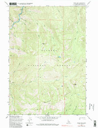
1969 Map of Parks Peak
USGS Topo · Published 1984About this map
The Salmon River and its South Fork converge in the northwestern corner of this territory, marking a significant hydrological junction within the Payette National Forest. This 1969 field-checked survey reveals a landscape defined by steep drainage systems and high-altitude points, including the prominent Parks Peak and Rainbow Ridge. The area is largely devoid of permanent settlements, focused instead on the remote infrastructure of the era such as the Lawman Ford crossing and various Pack Trails that navigated the complex terrain between Smith Creek and Savage Creek.
Find a feature on this map
31 named features on this map. Tap any name to fly to it.
Don’t see what you’re looking for? This feature index may not catch every label — zoom into the map to look around manually.
Map Details
Editions of this 1969 Parks Peak Map
3 editions found

Other maps of this area

1937 · Yellow Pine
USGS Topo · 1:48,000

1937 · Big Creek
USGS Topo · 1:48,000

1942 · Big Creek
USGS Topo · 1:62,500

1943 · Yellow Pine
USGS Topo · 1:62,500

1956 · Elk City
USGS Topo · 1:250,000

1957 · Challis
USGS Topo · 1:250,000

1960 · Elk City
USGS Topo · 1:250,000

1960 · Challis
USGS Topo · 1:250,000

1963 · Challis
USGS Topo · 1:250,000

1969 · Profile Gap
USGS Topo · 1:24,000