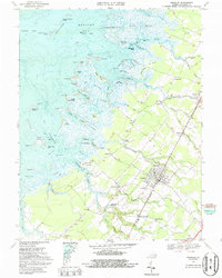
1968 Map of Parksley
USGS Topo · Published 1987About this map
Parksley serves as a primary rail-side hub on the Virginia Eastern Shore in the late 1960s, defined by its organized grid and the central corridor of the Penn Central railroad. This survey captures a landscape where agriculture and maritime life meet, with small communities like Whitesville, Lee Mont, and Hopeton dotting the interior highlands. To the west, the solid ground dissolves into a complex network of marshland and tidal guts, including Jimmys Gut and Young Creek, stretching toward the Bernard Islands and the open Thorofare. Local history is deeply etched into the geography through family-named landmarks such as Poulson Pt, Annis Pt, and Peters Hammock. The map detail reveals the importance of rural centers of worship like Bethel Ch and St Thomas Ch, alongside industrial remnants like Drummonds Millpond and the waterfront activity at Parker Landing.
Find a feature on this map
105 named features on this map. Tap any name to fly to it.
Don’t see what you’re looking for? This feature index may not catch every label — zoom into the map to look around manually.
Map Details
Editions of this 1968 Parksley Map
4 editions found
Other maps of this area

1903 · Crisfield
USGS Topo · 1:62,500

1920 · Crisfield
USGS Topo · 1:62,500

1931 · Accomac
USGS Topo · 1:48,000

1935 · Accomac
USGS Topo · 1:62,500

1942 · Chesconessex
USGS Topo · 1:31,680

1942 · Mappsville
USGS Topo · 1:24,000

1942 · Saxis
USGS Topo · 1:24,000

1942 · Parksley
USGS Topo · 1:24,000

1943 · Pungoteague
USGS Topo · 1:31,680

1943 · Parksley
USGS Topo · 1:31,680